print, paper, ink, engraving
#
baroque
#
dutch-golden-age
# print
#
paper
#
ink
#
geometric
#
cityscape
#
engraving
Dimensions: height 166 mm, width 197 mm
Copyright: Rijks Museum: Open Domain
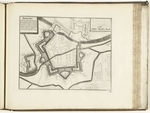
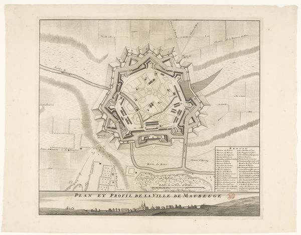
Curator: This meticulous engraving, titled "Vestingplattegrond van Sint-Winoksbergen," provides a detailed map of the fortified city, now known as Bergues, sometime between 1695 and 1711. It’s currently held in the Rijksmuseum collection. Editor: My immediate reaction is the stark geometry! The intricate web of lines describing the city's fortifications is really striking. It feels less like a guide and more like an abstract exercise in control. Curator: That controlled geometry speaks directly to the Dutch Golden Age, a time defined by meticulous order but also profound political anxieties, especially in relationship to territory and defense. This wasn't simply urban planning; it was a declaration of power through cartography. How does understanding the materiality of the print impact your analysis? Editor: Knowing this is an engraving shifts my perspective entirely. Each line, each minute detail was intentionally etched and printed. The labor is considerable! Thinking about the artist’s craft challenges the perceived neutrality of a simple, representational "map". Curator: Exactly. And think about how access to this kind of detailed knowledge might impact communities unevenly. Who commissioned it? Who used it? What social hierarchies are reinforced when geographical knowledge and defensive planning become accessible—or inaccessible—to different populations? Editor: It also raises questions about authorship and perspective. Whose vision of the city is being represented here? Whose values are embedded in the way space is depicted? I wonder about the working conditions and status of the engraver, as well as who the printmakers worked with on this endeavor. Curator: Absolutely. The Dutch Golden Age benefited from exploited labor in their imperial project, and this connects to seemingly disparate industries like printing and defence as integral cogs in its machinery. These maps served to legitimize the state's power, using visuality as a persuasive tool to justify the existing social and economic structures. Editor: I am reminded to examine beyond face value. Even in seemingly technical depictions such as this, choices of media, and who had control over these means, played a significant part in portraying certain values and power structures. Curator: Indeed. Seeing art and maps as evidence not only for geographical features, but also broader struggles relating to social identity, can illuminate a deeper, critical history.
Comments
No comments
Be the first to comment and join the conversation on the ultimate creative platform.
More like this