print, engraving
dutch-golden-age
geometric
cityscape
engraving
Dimensions: height 420 mm, width 526 mm
Copyright: Rijks Museum: Open Domain
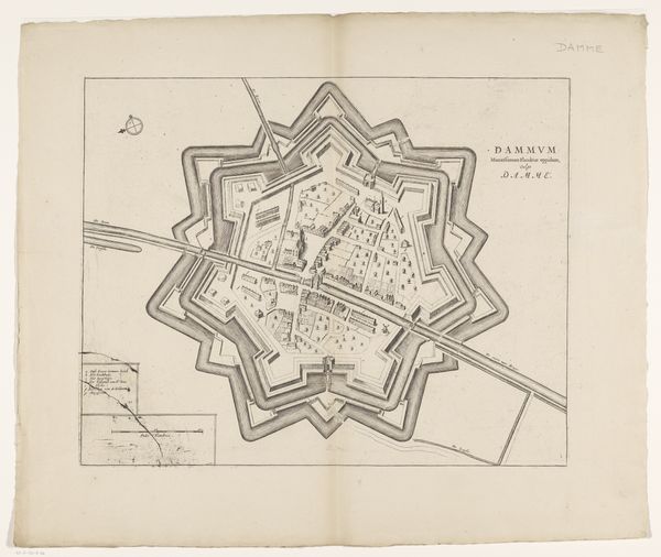
Curator: This engraving is titled "Plattegrond van Damme," dating back to 1652. It is the work of an anonymous artist during the Dutch Golden Age. Editor: The sharp angles of this star fort dominate the composition, immediately conveying military might and defensive architecture of the 17th century. Curator: Precisely. During the Dutch Golden Age, the Netherlands saw numerous innovations in mapping and cartography, driven by both commercial and military needs. The creation and circulation of these maps reinforced national identity. Note how Damme is visually defined and controlled, asserting Dutch dominance. Editor: It's also an impressive piece of craft. Consider the skill required to precisely render this complex design as an engraving. The labor and tools involved are implicit in every precisely etched line, no room for error in this mechanical printing process. The production itself would be a costly material investment with the printing process itself dictating the dissemination to a small percentage of the public. Curator: The formal, geometric style underscores a period obsessed with order, reason, and control. The detailed city layout is an implicit display of knowledge and a tool for exercising power, but to whom did that access to knowledge appeal to? Editor: The city within the fort shows little difference in building heights or styles which points to little hierarchical distinction. Perhaps a utopian model of urban planning is on display here; there's even gridding to promote accessibility in spite of being a fortified and somewhat enclosed cityscape. Curator: Possibly, but such clarity and geometric representation also impose a singular, dominant perspective. Think about the role this plays within military administration during an era marked by complex sociopolitical struggles in defining the region's borders and its public roles. Editor: True, this image ultimately reveals the militarized and calculated application of craft and materials, but such formal order can hide a network of human production, land development, and perhaps consumption that a conventional historic approach might sometimes overshadow. Curator: I concur, studying this "Plattegrond van Damme" offers insights into not only the ambitions of a nation but how mapping and urban control are reflected through materiality and artistry. Editor: Looking closer at the lines and considering their labor invites questions about its socio-economic accessibility during that period which provides new readings of urban landscapes.
Comments
No comments
Be the first to comment and join the conversation on the ultimate creative platform.