graphic-art, print, paper, engraving
#
graphic-art
#
baroque
#
dutch-golden-age
# print
#
paper
#
cityscape
#
history-painting
#
engraving
Dimensions: height 174 mm, width 215 mm
Copyright: Rijks Museum: Open Domain
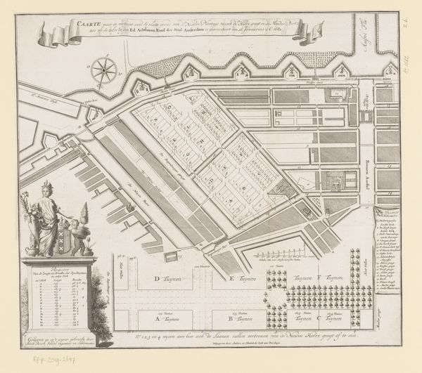
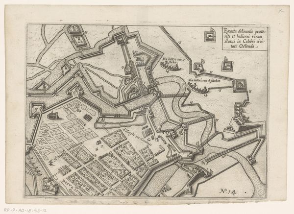
Curator: Here we have "Plattegrond van Delft," a cityscape from 1742, created using engraving on paper by an anonymous artist. Editor: At first glance, it’s a strikingly detailed map; almost a living portrait of the city. The lines are precise and meticulous, really highlighting the geometry of Delft. It has an orderly, almost regulated feeling. Curator: It’s intriguing how such detailed city maps served multiple purposes back then. While ostensibly functional, helping people navigate, they also communicated power, order and control. Cityscapes like this visually reinforced civic pride and identity. The use of graphic art and specifically the engraving technique were instrumental to distribute and proliferate the city's representation, shaping its identity among larger audiences. Editor: Absolutely, there’s that intersection between representation and lived experience. Who was this 'Plattegrond' for? How did its visual organization—that emphasis on order and clarity—impact how Delft residents saw their place in the world, or their relationship to authority? The historical context becomes key: in a rapidly urbanizing society, where did various groups—women, laborers, marginalized communities—fit into this neat, rationally planned city? Was the image simply reflecting reality or actively shaping a desired societal structure? Curator: I think you pinpoint the tension inherent to these historical cityscapes perfectly. There is, as you put it, the "lived experience" aspect of things, or rather the potential for discrepancy between representation and material realities of those excluded by that seemingly comprehensive organization. Editor: And consider that it’s part of the Rijksmuseum collection now – what’s the institution communicating by showcasing this piece? How do we frame such art today in light of contemporary discourse about urban development, inequality, and access? Curator: Indeed, that’s critical, forcing us to consider not just the history within the map, but the history of the map itself – it's public reception across eras and contexts, if you will. Editor: Examining this anonymous map compels us to challenge accepted narratives, prompting us to consider the diverse social relations imbedded within the urban fabric. Curator: It certainly pushes one to consider not only the depiction but the systems of power that framed it.
Comments
No comments
Be the first to comment and join the conversation on the ultimate creative platform.
More like this