graphic-art, print, etching, engraving
graphic-art
baroque
dutch-golden-age
pen sketch
etching
old engraving style
landscape
ink drawing experimentation
pen work
history-painting
engraving
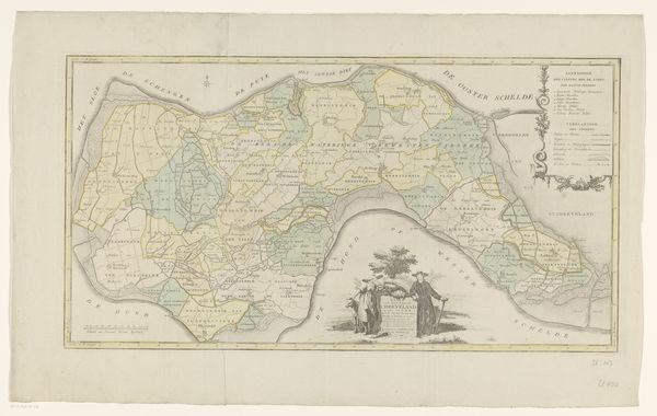
Dimensions: height 327 mm, width 623 mm
Copyright: Rijks Museum: Open Domain
This undated map of Schouwen-Duiveland is printed in ink on paper, a relatively inexpensive medium, which allowed for widespread distribution. The work's appearance is deeply influenced by its material. The ink creates sharp, definitive lines, which precisely outline geographical features. These qualities are essential for a map, where accuracy is paramount. The printing process also imbues the artwork with social significance. Maps like these weren’t just about geography. They were tools of power, allowing for territorial claims and resource management. This map, therefore, is not merely a document but a testament to human agency and a symbol of economic and political control. Understanding this requires looking beyond the image itself, and considering the social context and the labor involved in its production. It reminds us that even seemingly straightforward representations of the world are shaped by human intention and power dynamics.
Comments
No comments
Be the first to comment and join the conversation on the ultimate creative platform.