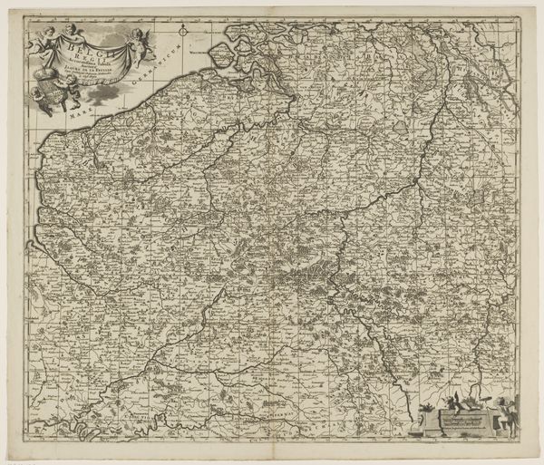
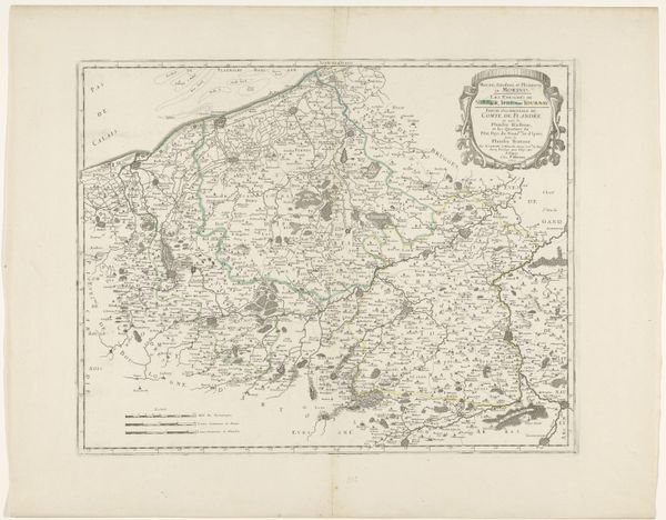
print, etching
#
baroque
# print
#
etching
#
landscape
#
etching
#
history-painting
Dimensions: height 509 mm, width 603 mm
Copyright: Rijks Museum: Open Domain
Curator: At first glance, it looks like an intricate spiderweb; a dense and detailed network meticulously drawn. There's something almost overwhelming in the sheer amount of information packed onto this single sheet. Editor: Indeed. What you are observing is an early 18th-century print, sometime between 1707 and 1719, of a map— "Kaart van het graafschap Vlaanderen", or "Map of the County of Flanders." This anonymous work is an etching currently held in the Rijksmuseum. The baroque style is evident. Curator: The visual language of the baroque certainly amplifies its power. And I appreciate that the etching is a reproduction of something existing—a literal attempt to dominate a portion of our known world via this detailed survey. Who gets to decide how space is defined or whose story gets inscribed onto such a public document? The figures in the corner—the reclining goddess, I presume?—what is she meant to convey? Editor: Mapping, in the 18th century, was deeply intertwined with power—military, economic, and political power. Detailed, accurate maps allowed for better navigation, resource exploitation, and military strategy. This is not a neutral representation; the inclusion of those figures aims to evoke a sense of classical authority and legitimacy of the County of Flanders and its rulers. They signify abundance and prosperity – likely used to promote its image to other political powers. Curator: So the landscape, rendered in such exquisite detail, becomes not just terrain, but also a stage upon which power dynamics are enacted, a visual manifestation of colonialism itself. Every city marked, every border defined, representing specific sociopolitical values projected upon land and populace. Editor: Precisely. Maps also served an important symbolic purpose—reinforcing a sense of shared identity and territorial unity within Flanders. Viewing this now allows us insight into 18th-century power structures as cartography intersected with governance. The meticulous detail elevates a survey document to political propaganda. Curator: Absolutely. Today, it offers space to analyze and dismantle the ideological forces at play through its creation, dissemination, and eventual archiving in spaces such as the Rijksmuseum. Editor: The complexities ingrained in an etching meant to serve practical and symbolic purposes—intriguing.
Comments
No comments
Be the first to comment and join the conversation on the ultimate creative platform.
More like this