print, etching, engraving
#
dutch-golden-age
#
mechanical pen drawing
# print
#
pen sketch
#
etching
#
sketch book
#
landscape
#
personal sketchbook
#
sketchwork
#
pen-ink sketch
#
pen work
#
sketchbook drawing
#
storyboard and sketchbook work
#
sketchbook art
#
engraving
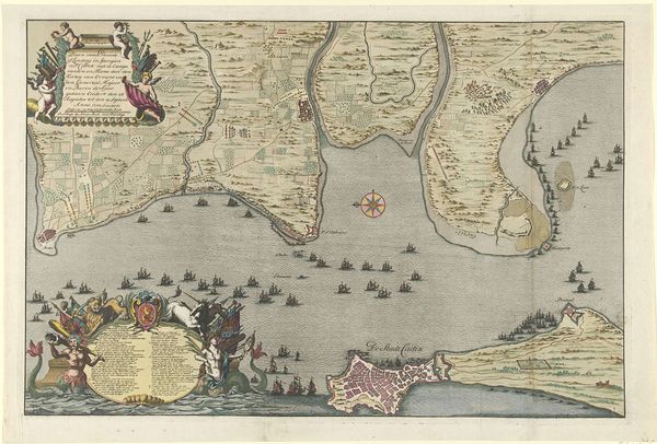
Dimensions: height 413 mm, width 449 mm
Copyright: Rijks Museum: Open Domain
In 1647, Salomon Savery made this map of the coast of Pernambuco using engraving techniques. The print on paper shows the coastline with careful, etched lines indicating geographical features and settlements. What makes this more than just a technical exercise is how it reflects labor, politics, and consumption. Look at the precision of the engraved lines; each one demanded careful work. Savery wouldn't have gone to Pernambuco, but instead worked from information received, and from other maps. The image of the tower and sugarcane production on the right highlights resource extraction by exploited labor. The ships, arranged in the sea, show the routes of trade. The lines create an image not only of place, but of power. This map isn't just an artistic object; it's a document of economic and social systems. Paying attention to the material and making allows us to think about its wider cultural meaning, beyond a conventional history of fine art.
Comments
No comments
Be the first to comment and join the conversation on the ultimate creative platform.
More like this