drawing, graphic-art, print, paper, ink, engraving
#
drawing
#
graphic-art
#
aged paper
# print
#
pen sketch
#
sketch book
#
landscape
#
paper
#
personal sketchbook
#
ink
#
geometric
#
pen-ink sketch
#
pen and pencil
#
pen work
#
sketchbook drawing
#
cityscape
#
genre-painting
#
history-painting
#
storyboard and sketchbook work
#
decorative-art
#
sketchbook art
#
engraving
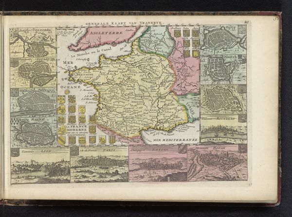
Dimensions: height 181 mm, width 258 mm
Copyright: Rijks Museum: Open Domain
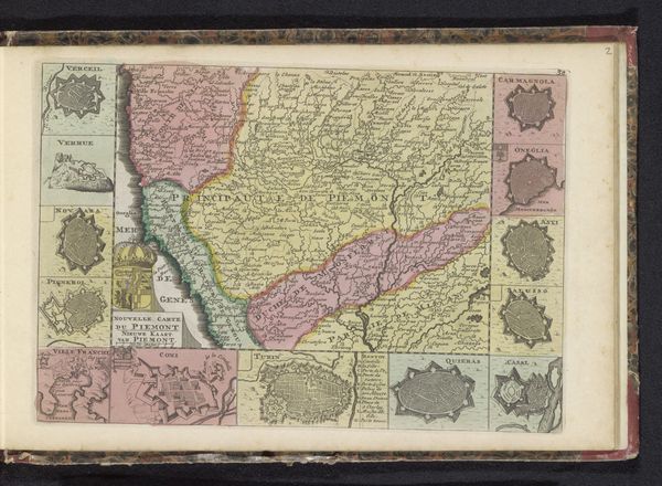
Curator: This is an anonymous work entitled “Kaart van de Dauphiné,” created sometime between 1700 and 1735, using engraving, ink and other graphic arts on paper. What's your initial impression? Editor: It feels simultaneously precise and fantastical. I'm drawn to the way the mapmaker intersperses bird’s-eye views of settlements around the central cartography. The variations in tone suggest a complex process of layering inks. Curator: Indeed, those small illustrations carry immense symbolic weight, don't they? They showcase key fortified cities and landscapes, projecting a certain vision of power and control. Note how geometric shapes and urban skylines interact. Editor: And they act almost like visual advertisements for the region. I’m particularly interested in the paper itself. Look at its texture—slightly aged, carrying the story of its creation, its material life and use. The value placed on recording places. Curator: Precisely, we must also reflect on the Dauphiné itself, positioned between the Kingdom of France and the Duchy of Savoy. This map serves not merely as geographic data but as a claim of territorial awareness, reflecting regional aspirations. Editor: That also resonates with me when considering who had access to such images, who was capable of consuming such imagery during the early eighteenth century? Curator: Access points to the symbolic capital of geographic and cultural knowledge at the time, a tool used in the negotiation of territorial identity. Editor: The engraver's hand seems particularly evident in those detailed cityscapes. We can infer much about the skill, labor, and techniques needed to produce this object. It begs the question, was this map a prototype for a broader printing? Curator: The absence of a named creator pushes us to appreciate the collaborative process behind mapmaking then, blending artisanal skill, surveying, and political will, its function more than merely geographic. Editor: Reflecting on the work, it’s hard not to appreciate how a map could signify an assertion of space, or control over access. Curator: Ultimately, it is a lens for viewing shifting cultural and political relationships expressed visually across generations.
Comments
No comments
Be the first to comment and join the conversation on the ultimate creative platform.
More like this