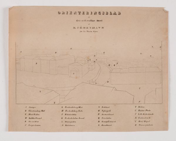
København set fra Nikolaj Tårn, orienteringsblad til den nordvestlige del 1837
0:00
0:00
drawing, print, paper, engraving
#
drawing
#
neoclacissism
# print
#
landscape
#
paper
#
cityscape
#
academic-art
#
engraving
Dimensions: 222 mm (height) x 291 mm (width) (bladmaal)
Søren Henrik Petersen created this orientational map of Copenhagen from the vantage point of Nikolaj Tower. It gives us a glimpse into the social and urban landscapes of early 19th-century Denmark. During this period, Copenhagen was undergoing significant transformation following the Napoleonic Wars. Petersen's detailed rendering provides insight into the city's spatial organization and architectural landmarks. The map not only highlights the physical structures but also subtly hints at the socio-economic divisions. You can see it in the contrasts between the more prominent, well-defined buildings, and the less detailed representations of residential or commercial areas. Looking at this piece, I am struck by how maps can serve as tools of power, dictating how space is perceived and understood. This map reflects the perspectives and priorities of its time, inviting us to consider whose stories are told and whose are left out. It offers a lens through which we can examine the relationship between urban development, social identity, and historical memory.
Comments
No comments
Be the first to comment and join the conversation on the ultimate creative platform.
More like this