drawing, graphic-art, mixed-media, print, paper, engraving
#
drawing
#
graphic-art
#
mixed-media
#
dutch-golden-age
# print
#
paper
#
engraving
Dimensions: height 485 mm, width 536 mm
Copyright: Rijks Museum: Open Domain
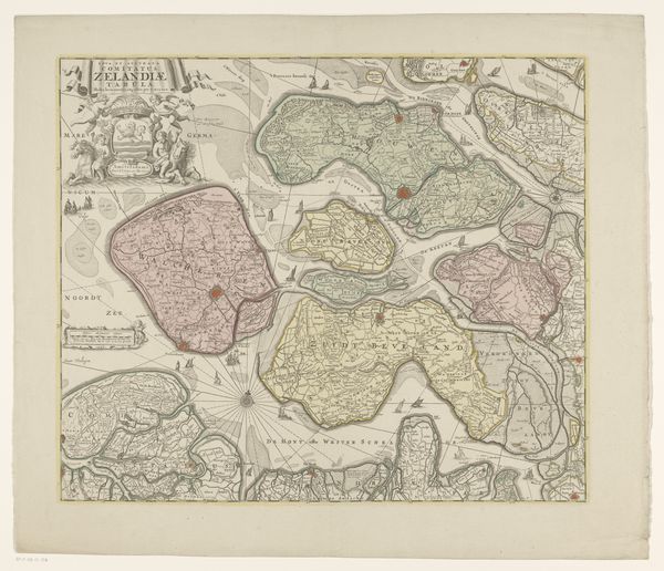
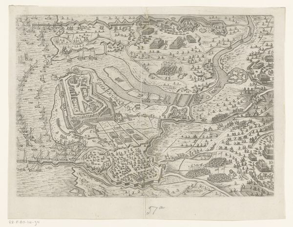
Curator: Looking at this engraving titled "Kaart van Zeeland," which translates to "Map of Zeeland," it feels like gazing into a fragmented past. The artwork dates from between 1787 and 1792. The piece employs mixed media, specifically drawing, graphic art, and print techniques to bring the cartography of this region to life. Editor: It's incredibly detailed; you can almost trace the trade routes. I’m drawn to the texture, though. You can see the mark-making in those fine lines—the artisan's hand is still visible in the printing process, despite its functional purpose. It makes one appreciate how painstakingly produced these maps would have been, as objects in and of themselves. Curator: Absolutely, and the materiality reflects a significant shift in how knowledge was disseminated during that period. The paper itself becomes a medium not only for representing geographic information but also for shaping public perception of territory. The visual language employed served political purposes, demonstrating control and asserting authority. How were such images consumed, beyond the obvious navigational applications? Editor: One wonders how widely accessible a print like this would have been. Consider the socio-economic conditions of the era; printmaking involved a complex system of labor, and its consumption probably reflected those class dynamics. Who owned these maps, what purposes did they truly serve, and what implications would such displays have within political circles? Curator: Indeed. Think about the culture surrounding maps – they were both practical tools and symbols of power and prestige. By meticulously depicting the province of Zeeland, this print embodies the spirit of the Dutch Golden Age, a time of economic and cultural prosperity built on maritime trade and exploration. So many vessels passing through; that must've been lucrative work for engravers who rendered images with fine details. Editor: It brings up the intersection of art and utility; the graphic details, the choices made in its production – they all reveal not just a landscape but also the prevailing beliefs, scientific methodologies, and trade imperatives that underscored 18th-century life in this maritime province. One gets a sense of an object functioning almost as propaganda of this golden era. Curator: And, in understanding this map, we can investigate the networks of power—cultural, economic, and technological—that shaped Zeeland and its relationship to the wider world. The hand that meticulously crafted it gives insight into a much broader cultural landscape, indeed. Editor: Exactly. By examining the material and the techniques employed, along with an understanding of history, we can glean the profound interplay of form and context. Thank you.
Comments
No comments
Be the first to comment and join the conversation on the ultimate creative platform.
More like this