print, etching, engraving
#
dutch-golden-age
# print
#
etching
#
landscape
#
etching
#
cityscape
#
engraving
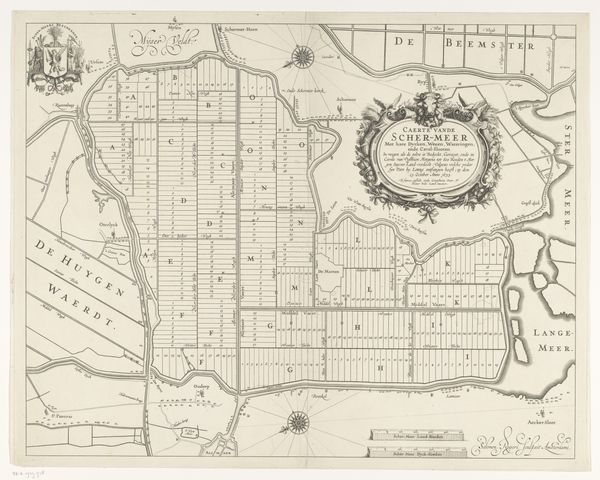
Dimensions: height 479 mm, width 607 mm
Copyright: Rijks Museum: Open Domain
Curator: Look at the fascinating level of detail! This print, likely dating from between 1673 and 1725, is titled “Kaart van Dordrecht en omliggende polders,” or “Map of Dordrecht and surrounding polders.” It comes to us from the hand of Bastiaen Stopendael. Editor: My first thought is "controlled chaos." You see this rigidly structured landscape of polders, these boxes hemmed by waterways, but the waterways themselves snake in wonderfully unpredictable patterns. There’s a real tension between human imposition and natural flow. Curator: Exactly! Considering the time, the deliberate ordering of land is key. The map embodies the Dutch Republic's struggle for autonomy. These polders weren't just geographical features; they represented political will, the desire to shape their environment and destiny, quite literally, against the powers of nature and, allegorically, Spain. The careful cultivation of land mirrors the careful construction of the Dutch state. Editor: Absolutely, and this ordering spills into symbolism. The very act of cartography feels loaded. Don't forget the heraldic crest! How about the classical figures framing the descriptive cartouche! A figure reminiscent of river gods points toward the city’s name! What is Stopendael trying to suggest about Dordrecht? Curator: We need to unpack what those allusions signify about early modern urban identity. The abundance denoted by the cornucopia contrasts with the engineered starkness of the landscape. Is this meant to suggest how far Dordrecht had come through marshland reclamation? To what extent were the marshland reclamation initiatives conceived by city planners from patrician families and wealthy merchants? Editor: Maybe! These images echo themes central to the idea of Dordrecht itself: human dominance over nature and the fruitful bounty of an industrious city, both carefully controlled. One has to wonder, what was included, and excluded from the rendering? This could change how contemporaries perceived their built and natural environments. Curator: Looking at this map today reminds me that all landscapes are political, deliberately shaped and meticulously presented, bearing within them a visual argument about power, identity, and control. Editor: For me, it shows the potency of symbols in imbuing physical places with layered meaning—turning earth, water, and geometry into statements of civic pride and the human spirit.
Comments
No comments
Be the first to comment and join the conversation on the ultimate creative platform.
More like this