graphic-art, print, engraving
#
graphic-art
# print
#
cityscape
#
engraving
Dimensions: height 308 mm, width 558 mm
Copyright: Rijks Museum: Open Domain
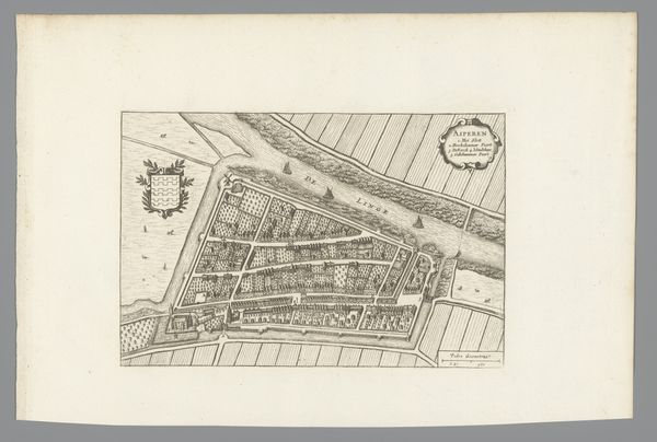
Curator: Here we have an intriguing print entitled "Plattegrond van Vlaardingen," which translates to "Map of Vlaardingen." Created anonymously between 1772 and 1775, this piece showcases a bird's-eye view of the city in the graphic-art medium. Editor: My initial impression is one of intricate detail. The lines are so precise; the visual balance between the density of the city and the openness of the surrounding land makes it aesthetically appealing, wouldn’t you agree? Curator: Absolutely. But its appeal lies deeper, embedded in its historical context. Cartography during this era served multiple purposes. Beyond navigation, city maps were symbols of civic pride and governance. They portrayed a community's spatial organization and socio-political hierarchies. Editor: Observe the deliberate use of engraving. Each line and form contribute to a cohesive, balanced composition that visually communicates structure. Even the seemingly neutral placement of land masses is strategically composed. Do you notice the hierarchy between urban and rural elements? Curator: Yes, the interplay reflects an ongoing power struggle. Note the clear distinction between the organized city center and the gridded farmland—this echoes the prevailing economic model. Furthermore, such maps played a crucial role in land management and property ownership during that time. Editor: Consider the function of this "cityscape" genre. The artist makes conscious visual decisions that allow us, the viewers, to decode this visual presentation of place. Beyond mere depiction, consider how the semiotic landscape enhances or alters our interpretation of this location. Curator: The placement of key landmarks is worth mentioning. Note the church steeple or town hall, these would have served not only as navigation points but also as symbols of societal and religious order. Such depictions further reinforced the existing social order, subtly legitimizing those in power. Editor: From a formal standpoint, it masterfully synthesizes texture with structural clarity to define an area. The detailed etching enhances both visual engagement and interpretive possibilities by inviting diverse interpretations based on its balanced spatial design. Curator: Ultimately, viewing "Plattegrond van Vlaardingen" transcends aesthetic appreciation; it provokes contemplation concerning urban planning's evolution as well as societal norms influencing public spheres across changing temporal contexts. Editor: And it demonstrates how careful compositional choices impact not just beauty but the communication of societal power relations. Fascinating.
Comments
No comments
Be the first to comment and join the conversation on the ultimate creative platform.
More like this