drawing, print, paper, engraving
#
drawing
#
dutch-golden-age
# print
#
paper
#
line
#
cityscape
#
engraving
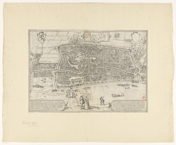
Dimensions: height 386 mm, width 530 mm
Copyright: Rijks Museum: Open Domain
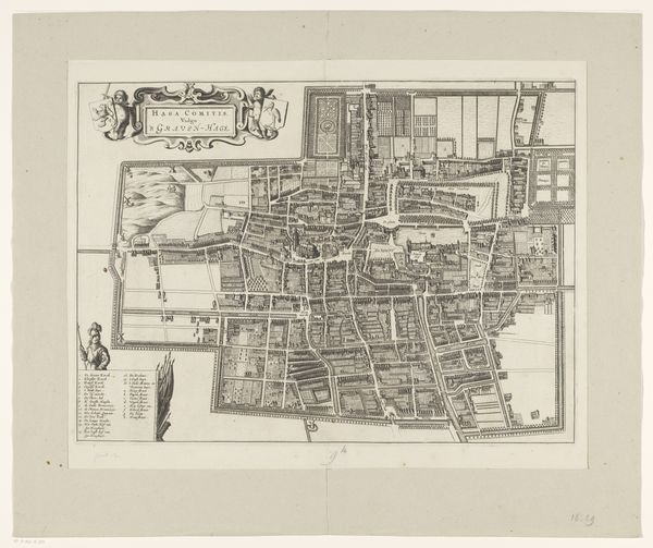
Curator: Immediately, the intricacy catches the eye. All those delicate lines packed together. It feels like a visual representation of societal planning and control. Editor: Indeed. What we are looking at is a work titled “Plattegrond van Den Haag”, an engraving on paper, that depicts a bird's-eye view of The Hague. While made by an anonymous artist, it resides in the esteemed Rijksmuseum. Dating suggests production occurred between 1657 and 1728. Curator: That broad time range itself speaks volumes. This wasn't a snapshot, but a representation that likely evolved with the city. I wonder how residents during this period viewed such images of their own spaces. Did it instill a sense of order, or perhaps alienation? Did the reality match the representation? Editor: Excellent questions. This image highlights the era’s interest in urban planning and societal governance, key concepts driving many Dutch Golden Age cities. These cityscapes served both practical purposes, assisting administration and commerce, while simultaneously functioning as a projection of civic power. It embodies the desire to visualize, to categorize, and ultimately, to control urban space. Curator: Control… I notice how every building, every waterway, is so neatly delineated. It almost denies the messiness of lived experience. Is this an aspirational map rather than a faithful one? Was there any consultation with the working class, women, the diverse communities within The Hague to ensure their existence or needs are visualized within such maps? Editor: Probably not. Though remember this map had functions to serve for commerce and administration, thus particular features are magnified and others are overlooked depending on the functions and social groups it had to serve. The map undoubtedly serves to promote power structures. Line-work technique in cityscapes, like this, has always highlighted certain structures while silencing marginalized inhabitants’ narratives. The visual precision arguably obscures underlying socio-economic inequalities of that period. Curator: So the image operates as a statement of intent, rather than simple representation, offering a window into both urban planning ideologies and societal power dynamics. Editor: Exactly, and how it shapes perceptions of identity and belonging. It pushes me to wonder: which narratives were prioritized and memorialized? What voices remained unmapped? Curator: Makes you look at a modern city map quite differently, doesn’t it? To consider what is shown, what is obscured, and whose city it is, truly.
Comments
No comments
Be the first to comment and join the conversation on the ultimate creative platform.
More like this