drawing, print, pen, engraving
#
drawing
#
baroque
# print
#
pen sketch
#
old engraving style
#
pen work
#
pen
#
engraving
Dimensions: height 396 mm, width 482 mm
Copyright: Rijks Museum: Open Domain
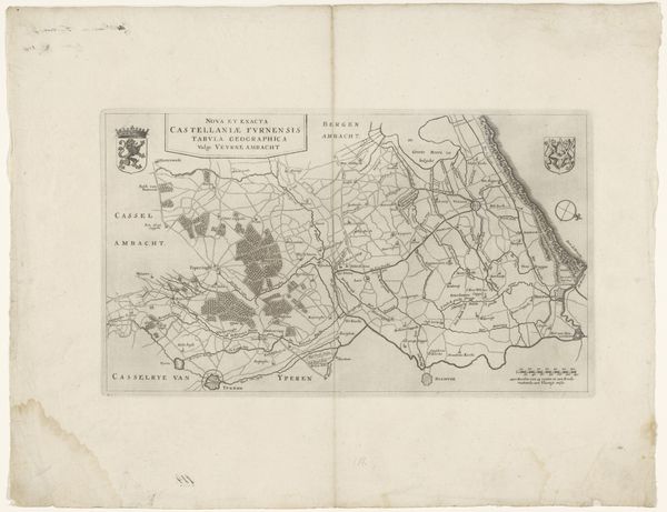
Curator: Before us, we have "Kaart van het bisdom Ieper," a map of the Diocese of Ypres dating back to 1735, rendered using pen and engraving. Editor: My first impression is the sheer density of information packed onto this single sheet! The lines are so fine and intricate, like looking at a spiderweb. There’s something both beautiful and unsettling about the attempt to contain and control geographical space. Curator: Absolutely. And considering the political climate of the 18th century, it’s fascinating to look at how mapping wasn't just about geographic accuracy, but a tool of power and control. Who commissioned this map, and what socio-political purposes did it serve? These questions become central. Was it for administrative purposes, military strategy, or perhaps even propaganda? Editor: Indeed, maps create realities. Notice the way different territories are defined and named – the clear delineation of the diocese itself. We might ask how this reinforces a particular power structure or potentially marginalizes others living outside those designated borders. What narrative is it pushing? Curator: Precisely! And thinking intersectionally, how might concepts of identity and belonging have been influenced by such cartographic representations? The church's power would’ve certainly been visually amplified through such clear spatial control. Editor: Right, seeing it as Baroque also, do you think it shows the exuberance of the era with an agenda or even an "I'm right" agenda of cartography? Curator: Yes, and note that this diocese was constantly fought over through centuries. I wonder whether this Baroque print and style are trying to imply the area's continued power, regardless of who controlled it? This may also indicate that there was an attempt to re-assure the residents of this place during turbulent times. Editor: These fine lines also act as subtle reminders of colonial ambitions woven through this seemingly innocuous landscape. Thank you! Curator: Indeed. Examining such works really underscores how maps serve as potent ideological instruments.
Comments
No comments
Be the first to comment and join the conversation on the ultimate creative platform.
More like this