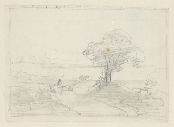
Kaart van het gebied tussen Den Bosch en Geertruidenberg met dijkdoorbraken (eerste blad) before 1757
0:00
0:00
drawing, print, paper, ink
#
drawing
#
light pencil work
#
dutch-golden-age
# print
#
pen sketch
#
pencil sketch
#
landscape
#
paper
#
personal sketchbook
#
ink
#
idea generation sketch
#
ink drawing experimentation
#
geometric
#
pen-ink sketch
#
sketchbook drawing
#
storyboard and sketchbook work
#
sketchbook art
Dimensions: height 304 mm, width 460 mm
Copyright: Rijks Museum: Open Domain
Editor: Here we have an intriguing map entitled "Kaart van het gebied tussen Den Bosch en Geertruidenberg met dijkdoorbraken (eerste blad)," made before 1757 by an anonymous artist. It's a print on paper using ink, detailing a region affected by dike breaches. What immediately strikes me is its documentary quality; it’s less picturesque landscape and more urgent record. What catches your eye in this piece? Curator: Ah, yes, maps. They always tell more than just geography, don’t they? I see a moment suspended—before 1757, to be precise. A time of vulnerability, meticulously captured. This isn't just lines on paper; it’s a story of human struggle against the relentless forces of nature, wouldn’t you say? The delicate ink work belies the potential for catastrophic events. Notice the compass rose, almost mocking in its ornate perfection, contrasting sharply with the breaches it attempts to chart. Editor: I do. The contrast you pointed out, between the artistic flair of the compass and the stark representation of the damaged landscape, does suggest a tension. Do you think the artist intentionally juxtaposed them? Curator: Intentionally? Perhaps not in a way we would consciously today. But artists *feel*. They channel anxieties and hopes into their work, perhaps unconsciously commenting on man's hubris in trying to control the natural world. Maybe this map is both a practical tool and a subtle warning – a beautiful one at that! A fleeting reflection of danger mapped as art. Editor: That's a compelling reading. I now see it less as a purely informational document and more as an expressive statement. Curator: Exactly. The lines are more like lyrical lines, an urgent song, forever echoing on paper. Art gives history a poetic tone.
Comments
No comments
Be the first to comment and join the conversation on the ultimate creative platform.
More like this