graphic-art, print, etching, engraving
#
graphic-art
# print
#
etching
#
linocut print
#
organic pattern
#
history-painting
#
engraving
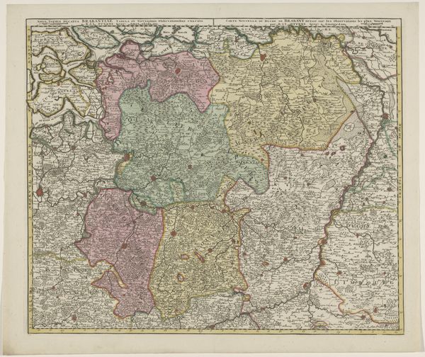
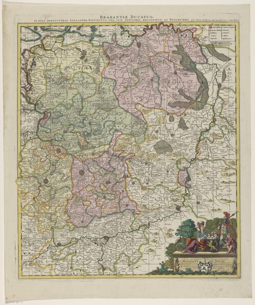
Dimensions: height 520 mm, width 616 mm
Copyright: Rijks Museum: Open Domain
Curator: Well, hello there. What do you think of this incredible antique map? The 'Kaart van het hertogdom Brabant' crafted sometime between 1678 and 1719 using etching and engraving. Quite stunning, don’t you think? Editor: My first thought? A delicious cake, perhaps almond flavored. It feels rich, detailed, with muted but defined regions, a tempting layout of shapes and colors all carefully outlined. I wonder what tales these old borders could tell? Curator: Precisely! It represents more than just geography, doesn't it? Brabant, now divided between the Netherlands and Belgium. Maps of this kind served not just as guides but as statements of ownership and identity. Editor: Absolutely. Boundaries, even imagined ones, are such powerful symbols. The act of mapping—claiming territory through representation. This map makes me ponder identity: what it means to belong, what we claim as our own. The soft colors evoke memory; I imagine looking at an old family album. Curator: You know, I imagine the creation process—the engraver meticulously translating surveyors' findings, imbuing the map with not just facts, but artistic flair too. Take a look at the heraldic crest; see how deliberately it is displayed. This was propaganda just as much as it was cartography. Editor: The crest anchors it, doesn't it? Those symbols scream power, authority. I’m particularly interested in how organic this so-called ‘scientific’ piece is; these borders squiggle like roots; everything flows and breathes like a living being. It challenges our understanding of imposed boundaries. Curator: Yes, indeed! Consider how such imagery would shape one’s view of their place in the world. Visual tools forming societal values, generation upon generation, the weight of expectation upon each town named! Editor: Makes you think about our contemporary cartography; do GPS and Google Earth create similar cultural and psychological spaces in our minds today? The technology evolves, but maybe our intrinsic need to map, order, and claim the world around us remains? Curator: It appears some cravings never fade away, eh? It all boils down to this: a map isn't just a depiction; it is an intention. An invitation to explore and stake your own claims… or maybe just imagine the almond flavored filling. Editor: Perhaps. A sweet way to remember history can be surprisingly affecting; just think about that idea that is buried beneath this piece! Thank you.
Comments
No comments
Be the first to comment and join the conversation on the ultimate creative platform.
More like this