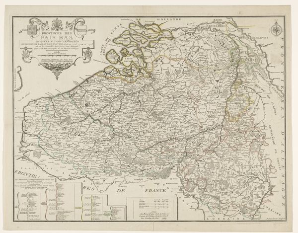
print, engraving
#
baroque
# print
#
line
#
cityscape
#
engraving
Dimensions: height 510 mm, width 605 mm
Copyright: Rijks Museum: Open Domain
Curator: This detailed map is entitled "Kaart van de Zuidelijke Nederlanden," or "Map of the Southern Netherlands," made sometime between 1721 and 1774, created as a print or engraving by Johannes L. van Luchtenburg. Editor: The fineness of the lines and the almost obsessive level of detail, even without vibrant colors, suggests authority and precision. It seems intent on communicating very specific information about this territory. Curator: Maps in this period were indeed powerful tools, both aesthetically impressive and deeply enmeshed in politics. They helped define territories, assert ownership, and shape national identity. Think about who the intended audience would be, who would be purchasing such a map and how they might use it. Editor: That makes me consider the symbolism here: boundaries so clearly drawn. Borders become performative acts of power in rendering the lines—what is left *out* of this depiction. Who decided what to include, and why? Curator: The "Southern Netherlands," primarily correspond to what is now Belgium, so the map illustrates a contested space caught between larger European powers, mostly Catholic regions formerly ruled by Spain. It appeared at a critical juncture, amidst ongoing conflicts and shifting alliances, and depicts not only geography but also the ambitions of empires. The printing medium itself would allow dissemination and reproduction to wider audiences who desired a sense of this place. Editor: Thinking of audience and dissemination brings into view the issue of accessibility. Who *could* read the labels, who could understand the complex delineations—what did it mean to produce such an ostensibly detailed image for consumers who are probably primarily elites? Curator: These kinds of details certainly point to this print serving a complex symbolic and practical function at the time it was released, influencing the political imagination. Editor: Ultimately, engaging with art history can inform not only an understanding of an artwork such as this, but also the historical milieu. Curator: Precisely, prompting us to reflect critically on how geographical depictions can perpetuate social, cultural, and political ideologies in both the past and the present.
Comments
No comments
Be the first to comment and join the conversation on the ultimate creative platform.
More like this