graphic-art, print, ink, engraving
#
graphic-art
#
baroque
# print
#
ink
#
cityscape
#
engraving
Dimensions: height 207 mm, width 267 mm
Copyright: Rijks Museum: Open Domain
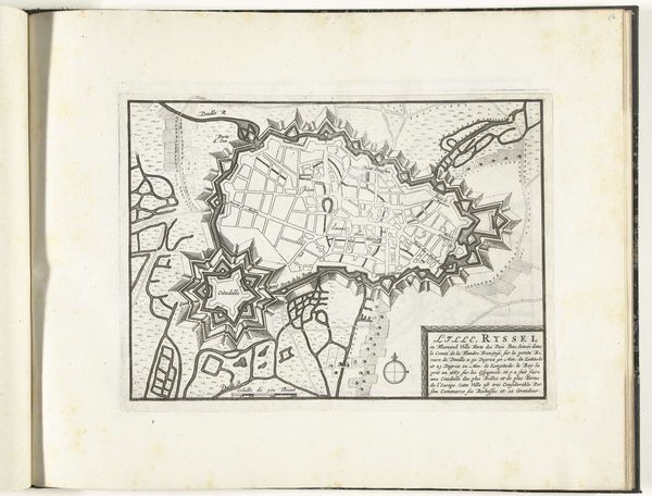
Curator: This is "Plattegrond van Lille, 1726", an engraving made in 1726. The map, now residing in the Rijksmuseum, is credited to an anonymous maker and rendered in ink using graphic arts techniques. Editor: It looks like an almost dreamlike projection. The level of detail, the meticulous representation of the fortifications... I'm struck by a sense of both vulnerability and power. It is a vulnerable record as it ages in front of us and displays power with the depiction of the subject itself, Lille. Curator: The map serves not only as a geographical guide but also as a symbol of civic pride and a strategic document, revealing Lille’s importance during a time of constant political maneuvering and warfare in the region. The baroque era adored this kind of representation! Editor: Look at the strong, almost floral, symbolism of the fortresses protecting the town. To me, this suggests how deeply cities of that period entwined ideas of beauty, power, and perhaps a touch of paranoia about outside forces. These shapes could not just be efficient military design, but they visually convey an identity. Curator: Absolutely. Cities understood their image was power, both within and to those looking upon the lands from the outside. The formal layout of streets contrasts with the more organic shapes of the fortifications and the terrain, emphasizing control and order versus the natural world. The image acts as propaganda by subtly celebrating urban planning as progress. Editor: I notice how even the title cartouche itself is full of visual cues: classical figures looking serenely down upon this precisely planned, well-defended urban landscape. They are all gazing down with a similar relaxed and proud look. The choice of placing those classical figures within the map suggests a continuity of civilization and hints at an unchanging, enduring spirit protecting this municipality. Curator: Considering that cities commissioned such work, this connection to an everlasting idea of security and control could indeed be at play. Editor: In essence, this piece highlights not just cartography but the deeply human act of creating symbols for the sake of identity, survival, and dominance, echoing even now in the maps that shape our perception. Curator: Yes, maps like these showcase the evolving interplay of civic power, military strategy, and the cultural aspirations of the cities that they represent.
Comments
No comments
Be the first to comment and join the conversation on the ultimate creative platform.
More like this