Dimensions: support: 2011 x 2600 x 40 mm
Copyright: © 2009 Jenny Holzer, member/Artists Rights Society (ARS), New York | CC-BY-NC-ND 4.0 DEED, Photo: Tate
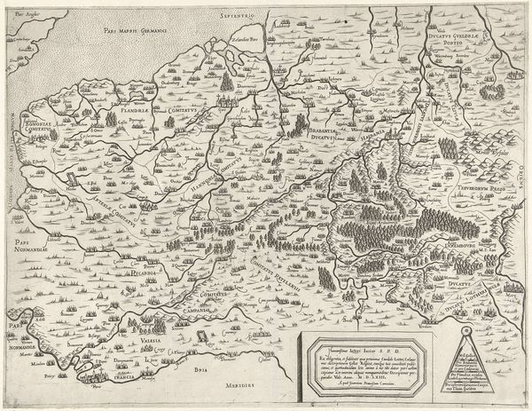
Curator: Jenny Holzer's "Protect Protect" presents a declassified document, offering a chillingly direct view into military strategy. What are your first thoughts? Editor: The severe violet monochrome immediately strikes me; it evokes a sense of cold calculation, as if drained of all emotion. Curator: Holzer's choice to reproduce this document as art invites us to consider the language of power and its impact on geopolitical realities. The words "Protect," "Suppress," "Exploit" take on new weight. Editor: The stark typography, the flat rendering of geographical space, all contribute to a feeling of detachment. It distances the viewer from the human cost. Curator: Absolutely. Holzer compels us to confront the ethical implications embedded within these strategic directives. It is a stark reminder of the human cost of war, and who is impacted. Editor: A potent synthesis of form and content, where visual austerity amplifies the disquieting nature of the message.
Comments
Join the conversation
Join millions of artists and users on Artera today and experience the ultimate creative platform.
tate 27 days ago
⋮
In this work by American artist Jenny Holzer, an image of a military map of Iraq has been screen-printed onto a linen canvas covered in a thin, translucent layer of violet oil paint. The map was first photocopied onto clear film, called a photo-stencil, which was used in the screen-printing process to transfer the image onto the canvas. The map features various labels, arrows and symbols. Three signs for military jets point towards the capital city of Baghdad, which lies almost at the centre of the screen print. Three labels reading ‘Protect’ frame the north, west and south sides of the map (where Iraq borders Turkey, Jordan and Saudi Arabia respectively). Around the map are various instructional labels, with the words ‘Suppress’, ‘Fix’, ‘Seize’, ‘Isolate’, ‘Shock and Awe’, ‘Exploit’ and ‘Gain Control’. (‘Shock and awe’ was a phrase used by the American government to describe its tactic of using overwhelming power during the invasion of Iraq in 2003.) These instructions suggest the defensive and offensive strategies of a military force. A box in the top right-hand corner notes details of the image’s declassification in June 2006.
More like this