drawing, print, paper, ink, engraving
#
drawing
#
baroque
# print
#
pen sketch
#
asian-art
#
paper
#
ink
#
geometric
#
engraving
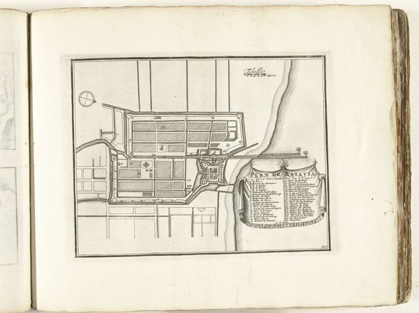
Dimensions: height 227 mm, width 289 mm
Copyright: Rijks Museum: Open Domain
This is a plan of Batavia, now Jakarta, created around 1693 to 1696 by an anonymous artist. Executed in pen and ink, the plan is a study in contrasts and control. The cartographer meticulously lays out the city's grid structure, where orderly blocks are juxtaposed against the natural curves of the coastline. The architecture is rendered with precision, with the rigid geometry softened by the organic flow of the water. The city's structure reflects the values of the Dutch East India Company. Here, we see the imposition of European order onto the Indonesian landscape. The formal qualities of the map communicate ideas of power, control, and the ambition to structure space, reflecting the colonial project of the time. The contrast between geometric city blocks and flowing coastline is a visual metaphor for the tensions inherent in this endeavor.
Comments
No comments
Be the first to comment and join the conversation on the ultimate creative platform.
More like this