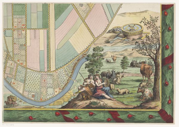
Plattegrond van de heerlijkheid Maarsseveen (deel linksonder) 1690 - 1691
0:00
0:00
philibertbouttats
Rijksmuseum
print, engraving
#
baroque
# print
#
landscape
#
cityscape
#
engraving
#
watercolor
Dimensions: height 454 mm, width 646 mm
Copyright: Rijks Museum: Open Domain
Philibert Bouttats created this section of a map of Maarsseveen in the Netherlands, sometime between 1675 and 1708. Maps like these aren’t just about navigation. They reflect the power and aspirations of the people who commissioned them. Notice how this map is adorned with cherubs, fruit, and figures from classical antiquity. These elements elevate a practical document to a work of art, signifying the wealth and sophistication of the region and its owners. The bear on the coat of arms suggests a connection to local nobility or signifies the importance of the region for hunting. By looking at archival records of land ownership, family histories, and economic data from the period, we can better understand the social dynamics and power structures represented. Maps can tell us much about the values of a culture. They highlight what that culture wants to celebrate, preserve, and pass on to future generations.
Comments
No comments
Be the first to comment and join the conversation on the ultimate creative platform.
More like this