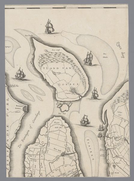
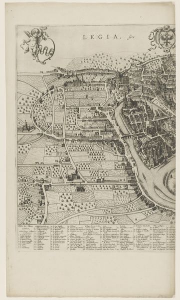
Kaart van het Hoogheemraadschap van Delfland, met 's-Gravenzande en omgeving, deel linksonder 1611 - 1692
0:00
0:00
florisbalthasarszvanberckenrode
Rijksmuseum
drawing, ink, engraving
#
drawing
#
pen sketch
#
landscape
#
ink
#
engraving
Dimensions: height 382 mm, width 312 mm
Copyright: Rijks Museum: Open Domain
Curator: Look at this captivating map—it's titled "Kaart van het Hoogheemraadschap van Delfland, met 's-Gravenzande en omgeving, deel linksonder," placing us in the Delfland region sometime between 1611 and 1692. The piece appears to employ both ink and engraving, offering an incredibly detailed look at the landscape. Editor: My first impression? Waves of relentless industry meticulously plotted onto parchment. There's an overwhelming sense of organization battling the wildness of the sea. Just look at the density of line work. Curator: Precisely. Floris Balthasarsz van Berckenrode really showcases how much human intervention has gone into shaping this coastal land. I see stories of laborious land reclamation efforts etched within each line and curve. Canals acting like veins to the area! Editor: Indeed. Beyond any romanticism of "landscape," this drawing screams material concerns: how do you manage water? Where does the funding come from? These maps weren't aesthetic exercises; they dictated real work, budgets, and social organization. How much did the engravers earn for a sheet like this, I wonder? And who used this image in their daily workflow? Curator: It makes you wonder about their understanding of perspective! Beyond mere representation, the landscape transforms into a theater, full of untold and everday stories, not grand tales necessarily. Each field or tiny ship out at sea likely holds memories, secrets even, just lost to time. It's all beautifully mysterious to me! Editor: Oh, there is undoubtedly beauty. The swirling compass rose and decorative flourishes along the bottom remind me of lavish display; this isn't *just* a working document but something meant to inspire a sense of civic pride, perhaps, or display authority. Note the strategic place-names of key towns; those engravings surely were meticulously planned from every viewpoint! Curator: Yes, but don't you also think the stark contrasts and intricate details could hint at a deep, perhaps spiritual, connection to their land, their own reality of this waterwork management? All captured through what feels to me an extremely personal language? Editor: I think connecting material labor and daily maintenance with the bigger picture of a changing landscape is the biggest testament to this print’s cultural worth and value within the frame. A feat for one pen and some engraved metal. Curator: And for me, that feat echoes quietly across the centuries; the land whispers stories back, connecting us intimately to its past keepers.
Comments
No comments
Be the first to comment and join the conversation on the ultimate creative platform.
More like this