lithograph, print, engraving
#
lithograph
# print
#
landscape
#
cityscape
#
engraving
Dimensions: height 416 mm, width 325 mm
Copyright: Rijks Museum: Open Domain
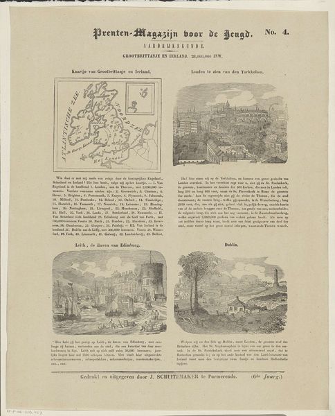
This print of Great Britain and Ireland, including depictions of London, Edinburgh and Dublin, was created by Jan Schuitemaker in the Netherlands. Likely intended for educational purposes, this print is deeply embedded in a specific social and cultural context. The choice of imagery constructs meaning through visual codes. The map emphasizes geographical boundaries, reinforcing a sense of national identity. The inclusion of London's "York Column" signifies British imperial power and its connection to classical grandeur. Meanwhile, the images of Leith and Dublin represent bustling ports, crucial to trade and economic growth. Made at a time of rising nationalism and industrial expansion, this print speaks to the social structures of its time. The emphasis on population numbers and economic activity underscores the importance of national strength and competitiveness. To truly understand this artwork, it requires an understanding of its contemporary institutions, the prevailing social attitudes, and the economic forces that shaped its production. Researching Dutch printmaking traditions, British imperial history, and the history of geography as a discipline would provide the necessary insight. Only then can we unlock the full story of this seemingly simple print.
Comments
No comments
Be the first to comment and join the conversation on the ultimate creative platform.
More like this